 An Introduction to SEDRIS: |
 Tutorial Abstract |
 Background: The DoD Net-Centric Strategy |
 Background: How SEDRIS relates to the DoD Net-Centric Strategy |
 Current Environmental Data Challenges |
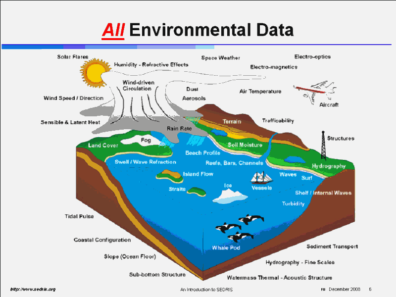 All Environmental Data |
 The SEDRIS Solution |
 Interoperability: Environmental Data Used for Different Applications & Purposes |
 Factors to Include in Addressing the Common Environmental Model |
 Factors to Include in Addressing the Common Environmental Model |
 Army Guidance � from the Army (G3) Geospatial Data Integration Master Plan (AGDIMP) |
 How SEDRIS is used - Conceptual |
 Examples of Integrated Data |
 Examples of Integrated Data - urban/interior |
 Examples of Integrated Data - inspection |
 Examples of Integrated Data - undersea |
 Examples of Integrated Data - urban |
 Examples of Integrated Data - weather effects |
 Data Sharing Using a Standards-based Middleware Approach |
 SEDRIS Is� |
 What Does SEDRIS Do |
 SEDRIS can be used to build� |
 Key SEDRIS Concepts |
 SEDRIS Technology Components |
 SEDRIS ISO / IEC Standards |
 A Team-based Open Development Approach |
 International Participation |
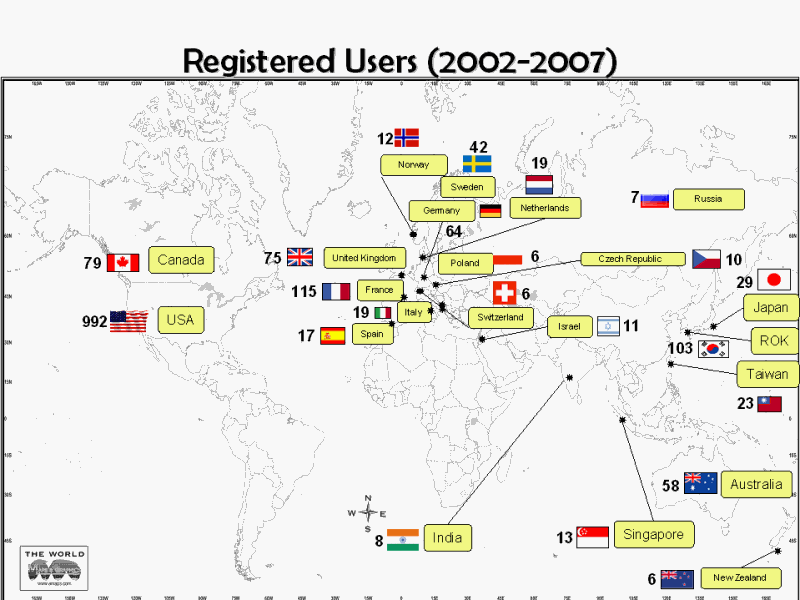 Registered Users (2002-2007) |
 Examples - SEDRIS in Use - past & present |
 Examples - SEDRIS in Use - past & present |
 Continuing Goals |
 Using the SEDRIS Components |
 Same Object - Differing Views |
 Different Representations of the Same Environment |
 A DRM for the Environment |
 From DMs of the Environment � to a DRM for the Environment |
 Environmental Data Challenges |
 Solving Environmental Data Challenges |
 Solving Environmental Data Challenges |
 Related Standards, Efforts, & Projects |
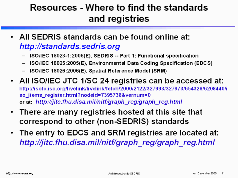 Resources - Where to find the standards and registries |
 Registerable Items for SEDRIS Standards |
 Registerable Items for SEDRIS Standards (cont�) |
 PPT Slide |
 PPT Slide |
 SRM Requirements |
 SRM Conceptual Relationships |
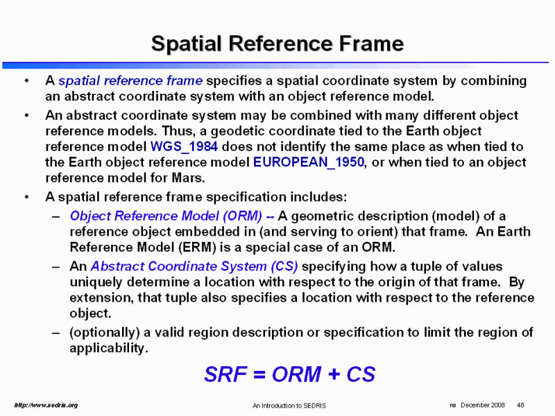 Spatial Reference Frame |
 Spatial Reference Frame Templates (SRFT) |
 SRM registerable concepts |
 SEDRIS Spatial Reference Frames |
 PPT Slide |
 Environmental Data Coding Specification |
 Vehicles (and Life forms) |
 Furniture, Openings, Equipment |
 Rooms / Compositions |
 EDCS Basics (1) |
 EDCS Basics (2) |
 Required Content for EDCS Concepts Registration |
 Related Standards |
 PPT Slide |
 The DRM in relation to SRM, EDCS |
 DRM Basics |
 DRM Basics |
 DRM Summary |
 PPT Slide |
 SEDRIS Transmittal Format (STF) |
 Transmittal Format - Requirements |
 STF Design Features |
 PPT Slide |
 The SEDRIS API |
 The APIs |
 Transmittal Access API Summary |
 The SRM API |
 The EDCS API |
 The DRM API |
 How the Five Components Relate |
 How to Apply SEDRIS Technologies |
 PPT Slide |
 Many SEDRIS-based tools, utilities, and applications exist |
 Ocean Profile viewer |
 Acoustic Ray Trace viewer |
 SEDRIS in Korean applications |
 Synthetic Environment Evaluation - Inspection Tool (SEE-IT) |
 PPT Slide |
 Water Surface Polygon with High Slope |
 PPT Slide |
 PPT Slide |
 Comparison with Current Practice |
 Side-by-Side viewer |
 SEDRIS Navigator |
 Display Components |
 Wind Map |
 Summary - SEDRIS |
 More information |
. |