 PPT Slide |
 SRM Tutorial |
 Prerequisite |
 PPT Slide |
 PPT Slide |
 Section I |
 In the Beginning ... |
 PPT Slide |
 Simulation Interfaces |
 Other Interoperability Examples |
 SRM Requirements |
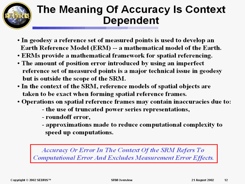 The Meaning Of Accuracy Is Context Dependent |
 Why is Accuracy Needed for Coordinate Transformations? |
 PPT Slide |
 It�s a Loooong Way Up |
 The SRM Encompasses More Than The Earth |
 The Scope Of The SRM |
 The SRM Requires a Shared Solution |
 Structure of the SRM ISO Standard |
 Structure of the SRM ISO Standard |
 Section II |
 So How Will We Get There? |
 Coordinates |
 2-D Rectilinear Coordinate Systems |
 Curvilinear Coordinate Systems(1 of 2) |
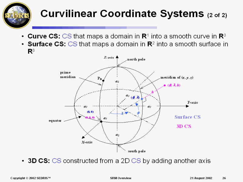 Curvilinear Coordinate Systems (2 of 2) |
 Projection-based Coordinate Systems |
 Spatial Referencing |
 Indirect Embeddings |
 Example: Vancouver_2002 |
 Example: Vancouver_2002 Cont�d |
 Example: Vancouver_2002 Cont�d |
 Spatial Reference Frame |
 Reference Datums (1 of 4) |
 Reference Datums (2 of 4) |
 Reference Datums (3 of 4) |
 Reference Datums (4 of 4) |
 Reference Datum Set |
 Orthonormal RDS Class |
 Oblate Spheroid RDS Class |
 Infrastructure Review |
 Section III |
 Development of Surfaces to Generate Maps |
 Projecting from 2D to 1D |
 Distance Distortion Can Be Mitigated, Somewhat |
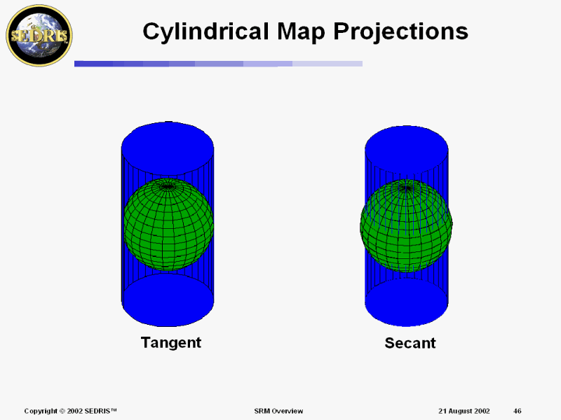 Cylindrical Map Projections |
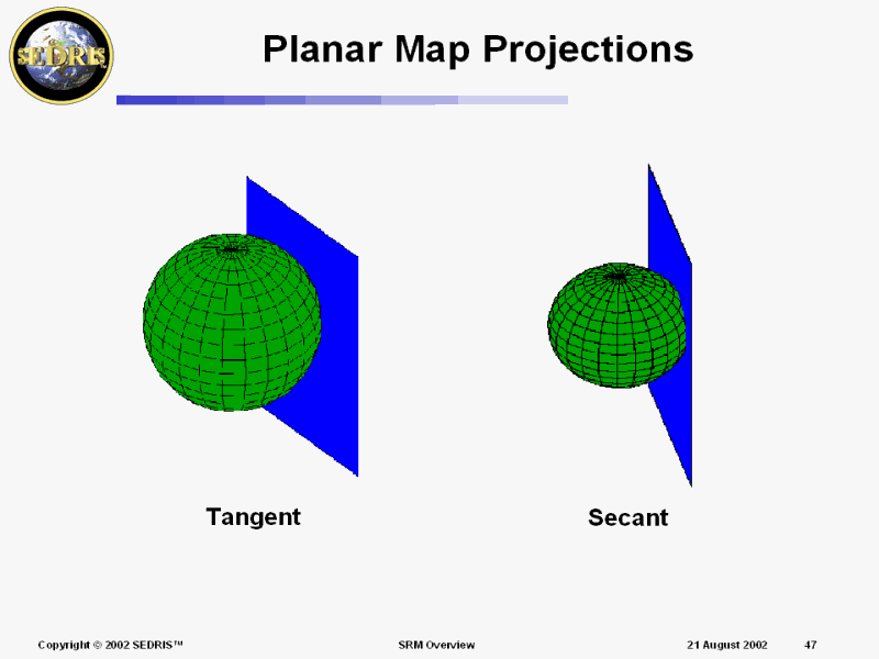 Planar Map Projections |
 A Stereographic Map Projection |
 Conic Map Projections |
 Mercator Map Projection |
 Oblique Mercator Map Projection* |
 The Grid for Transverse Mercator* |
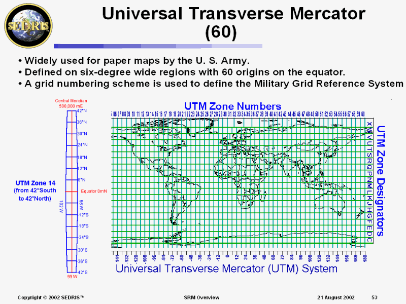 Universal Transverse Mercator (60) |
 Lines of Constant Heading* |
 Great Circle Arc between Moscow and Washington D.C.* |
 Augmented Projection-Based SRFs |
 Projection-based �3D� SRFs |
 The Use of Augmented Systems Changes Geometrical Relationships |
 SRF Operation Relationships |
 Geometric Distortions |
 Augmented map projection vertical distortion |
 Flattening the ORM: Distance and Geometry |
 Placing a Solid Cube on an OBS |
 Doing the Math ... |
 Placing a Cube on the Topographic Surface Model |
 Long Linear Structures |
 Vectors in Augmented Projection-based SRFs |
 Vectors in a Curvilinear System |
 Defining a Canonical Local Tangent Plane SRF |
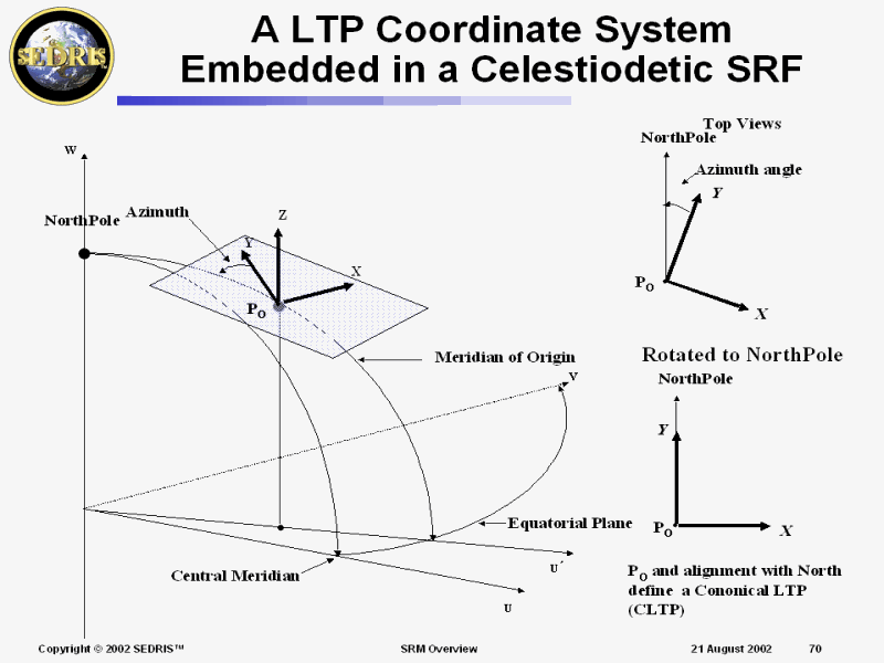 A LTP Coordinate System Embedded in a Celestiodetic SRF |
 Defining a CLTP Embedded in a Celestiodetic SRF |
 Reference Vectors |
 Reference Vector Transformations |
 Convergence of the Meridian |
 SRF �North� may not be True North |
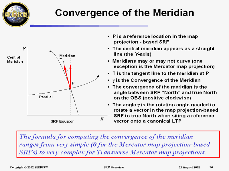 Convergence of the Meridian |
 Section IV |
 ORMs vs. Object Models |
 Celestial Object Models |
 Example: Earth |
 Earth Surface Model Terminology |
 Section V |
 Spatial Operations |
 Spatial Operations |
 Coordinate Conversion |
 Coordinate Transformation |
 Spatial Reference Model |
 Quality Assurance for Spatial Operations |
 Conformance Verification for the SEDRIS Implementation |
 Acceptance Testing Methodology |
 SRM Concept Management |
 SRF Relationships |
 Section VI |
 Why is Accuracy Needed for Coordinate Operations? |
 Shooting at a Visible Target in the Real World |
 Simulation of Shooting at a Visible Target |
 Servicing a Non-visible Target in the Real World |
 Error Sources in Coordinate Operations Software |
 Definition of Computational Error |
 Numerical Methods |
 Analytic (closed form) Solutions |
 Taylor/Maclaurin Series Methods |
 Iterative Methods |
 Direct Approximation of a Function or Its Inverse |
 Direct Approximation of a Function or Its Inverse (cont) |
 Error in Power Series Expansions |
 Error Analysis and Resolution of Disagreements |
 Effect of Small Errors |
 Fuzzy Creep/Coordinate Drift |
 Bounds Checking |
 Distortion in Map Projection-based SRFs |
 Treatment of Point Scale |
 Distortion and Computation Error Tradeoff |
 Distortion-Accuracy Tradeoff Experiment for TM |
 Authoritative Sources Sometimes Appear to Disagree |
 Difference between SR-7 & Extended Formulas for Transverse Mercator |
 Transverse Mercator Map Projection Point Scale Equations |
 Linear Distortion Error For TM |
 Conclusions of Experiment |
 What to Do? |
 The Chaining Problem |
 Section VII |
 Modelers Often Prefer Orthonormal Coordinate Systems |
 Euclidean Distance for an Orthonormal System |
 Once the Environment is Included, there are Many Feasible Paths |
 Geometry Distorting 3-D SRFs are often Used � Why ? |
 Section VIII |
 SRFs in the DRM |
 DRM <Location> (Sheet 15) |
 SRFs Supported |
 Section IX |
 PPT Slide |
 ERM Datum Transformations |
 WGS84 Geoidal Separation |
 PPT Slide |
 Types of Operation Errors |
 �Valid� Coordinates |
 Coordinate Validity |
 Implementation Details (1 of 2) |
 Implementation Details (2 of 2) |
 Range Extension (1 of 2) |
 Range Extension (2 of 2) |
 PPT Slide |
 Operation Implementation Status |
 Coordinate Operation Chains |
 Interface Specification(s) |
 Status Codes (1 of 3) |
 Status Codes (2 of 3) |
 Status Codes (3 of 3) |
 Operation Setup |
 Change SRF Operation |
 Multi-change SRF Operation |
 Boundary Checking |
 Operation Teardown |
 Vector Operation |
 Matrix Operation |
 Convergence of the Meridian |
 Further Reading |
. | . |