Class Name: Spatial Index Related Features
Subclasses
This DRM class is concrete and has no subclasses.
Definition
An instance of this DRM class specifies a spatially indexed related
aggregation representing a collection of
<Feature Hierarchy> components in which each
<Feature Hierarchy> component represents a different tile
within this aggregation. The <Spatial Index Data> link object
corresponding to each <Feature Hierarchy> component
indicates which tile it represents.
Primary Page in DRM Diagram:
Secondary Pages in DRM Diagram:
This class appears on only one page of the DRM class diagram.
Example
Consider a <Spatial Index Related Features> instance with
row_count = 1,
column_count = 4,
row_width =
1000 metres,
column_width = 500 metres.
For simplicity, each of the four branches of the
<Spatial Index Related Features> instance in this example is a
<Union Of Features> instance, as depicted in
Figure 60:
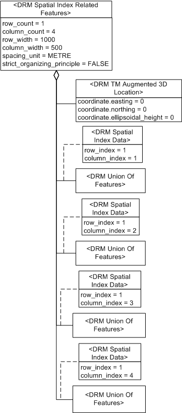
Figure 60 — <DRM Spatial Index Related Features> feature example
Since the origin of the collection (its lower left corner, the
<TM Augmented 3D Location>
component) is (0, 0, 0), the coverages of the branches are:
- from (0, 0) to (500, 1000)
- from (500, 0) to (1000, 1000)
- from (1000, 0) to (1500, 1000)
- from (1500, 0) to (2000, 1000)
NOTE
A <Spatial Index Related Features>
instance does not specify the range of z/height/elevation values.
Consider a triangular <Areal Feature> instance
in branch #2 of the previous example's aggregation,
consisting of one regular
<Feature Face> instance, which in turn
has an external <Feature Face Ring> instance
containing three <Feature Edge> instances
as depicted in Figure 61:
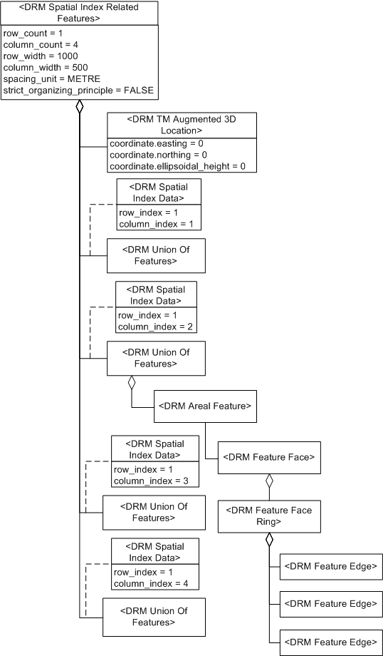
Figure 61 — <DRM Spatial Index Related Features> topology example
Since the <Areal Feature> instance thus
crosses the boundary between branch #2 and branch #3, the
<Spatial Index Related Features>
instance's
strict_organizing_principle
is set to SE_FALSE.
FAQs
-
A particular data provider's data consists of a collection of
<Areal Feature> instances that are tiled along
the lines of a grid, but some <Areal Feature>
instances here and there cross over tile boundaries. Can these
<Areal Feature> instances be organized with a
<Spatial Index Related Features>
instance?
Yes, if its
strict_organizing_principle
is set to
SE_FALSE to indicate
that the indexing is not strictly followed (see examples).
Each tile of the spatial index is represented by a
<Feature Hierarchy> component
of the
<Spatial Index Related Features>
instance.
Constraints
Associated to (one-way) (inherited)
Associated by (one-way) (inherited)
Composed of (two-way) (inherited)
Composed of (two-way)
Composed of (two-way metadata) (inherited)
Component of (two-way) (inherited)
Notes
Associated to Notes
An association between two
<Feature Representation> instances
indicates that the environmental object(s) that they
represent have the semantic relationship indicated by
the <Base Association Data>
link object on the association relationship.
An association between a
<Geometry Hierarchy> instance and a
<Feature Representation> instance
indicates that the environmental object(s) that they
represent have the semantic relationship indicated by
the <Base Association Data>
link object on the association relationship.
An association between a
<Property Grid> instance and a
<Feature Representation> instance
indicates that the environmental object(s) represented by the
<Feature Representation> instance
and the <Property Grid> instance
(or some specific cell data within that
<Property Grid> instance) have the
semantic relationship indicated by the
<Base Association Data> link object
on the association relationship. Each associated
<Property Grid> instance indicates
whether the entire <Property Grid>
instance or only some specific cell data within it is participating
in the relationship in question.
Associated from Notes
An association between two
<Feature Representation> instances
indicates that the environmental object(s) that they
represent have the semantic relationship indicated by
the <Base Association Data>
link object on the association relationship.
An association between a
<Geometry Hierarchy> instance and a
<Feature Representation> instance
indicates that the environmental object(s) that they
represent have the semantic relationship indicated by
the <Base Association Data>
link object on the association relationship.
An association between a
<Property Grid> instance and a
<Feature Representation> instance
indicates that the environmental object(s) represented by the
<Feature Representation> instance
and the <Property Grid> instance
(or some specific cell data within that
<Property Grid> instance) have the
semantic relationship indicated by the
<Base Association Data> link object
on the association relationship. Each associated
<Property Grid> instance indicates
whether the entire <Property Grid>
instance or only some specific cell data within it is participating
in the relationship in question.
Composed of Notes
The <Image Mapping Function> components
support texture mapping information
for geometry that is to be derived from the
<Aggregate Feature> instance
by the consumer.
These <Image Mapping Function>
instances shall use <Image Anchor>
components to specify the mapping.
A <Presentation Domain> component is needed for
<Aggregate Feature> instances that are
significant only for a particular domain, such as radar.
The <Location> component is the origin of the collection,
which is the lower left corner.
Fields Notes
If the value of the
unique_descendants
field is SE_TRUE, each
descendant shall be unique in the sense that it shall
appear in only one branch of this aggregation.
Each descendant is a <Feature Representation> instance
within the component tree rooted at the
<Aggregate Feature> instance.
If unique_descendants
is SE_FALSE, at least one
<Feature Representation> instance
appears in more than one branch of the aggregation.
If the value of the
strict_organizing_principle
field is SE_TRUE, each
branch of this aggregation
strictly complies with the organizing principle for its
particular subclass. If this value is
SE_FALSE, at least
one branch does not strictly comply with the given
organizing principle. See the organizing principle constraint
for each specific subclass for details.
If the value of the sparse field
is SE_FALSE,
all column and row entries are present;
otherwise one or more entries are not present.
The column_count field
specifies the number of cells along the primary axis.
The row_count field
specifies the number of cells along the secondary axis.
The column_width field
specifies the length of a cell in the given unit along the primary axis.
The row_width field
specifies the length of a cell in the given unit along the secondary axis.
The spacing_unit field
specifies the unit of measurement for
column_width and
row_width.
Prev: Spatial Index Related Feature Topology.
Next: Spatial Index Related Geometry.
Up:Index.